Monday, November 28, 2022

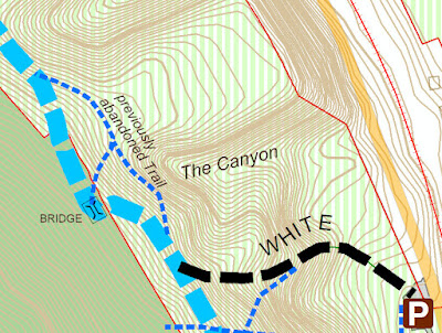
Emergency Paugussett Trail Relo at the Indian Well Canyon


New trail location is in purple

The Paugussett Trail had to be moved up the hill once again as a rapidly eroding gully ("the Canyon") advances up the slope. There are sharp, unstable drop-off at the head of the gully, which has now bisected the entire state park and is moving into Shelton Land Trust property. This is located near the main trailhead parking area across the street from the beach entrance, above the flight of 50+ steps. 

Head of the gully a few years ago, bridge at the upper right

This is how deep the head of the gully was in 2018

The bridge was formerly located 100 feet down the hill, but was moved up the hill to escape the advancing gully maybe 20 years ago. The Canyon has been relentless, however, and is nearing the bridge once again. 

Part of the latest relocation

A few years back, we did an emergency relocation on the north side of the bridge after discovering the deep trench-like gully near the trail. The head of the gully was so narrow at that point in time that is resembled a 10-foot deep construction trench. It was so narrow that you couldn't even see it until you were nearly in it. This year, it was the same scenario, but on the south side of the bridge. 

Previous trail relocations

The Canyon is impressive, and anyone interested in surficial or glacial geology should check it out. It would be a great location for a geology class field trip. The sandy soil here was once the bottom of a glacial lake, so some interesting cross bedding and other features were exposed:


Paugussett Reroute at Eversource Towers

New trail route avoids powerline work set for 2023

Two work parties were held in November to move a section of Paugussett Trail away from some powerline towers that will be replaced in 2023.  The trail reroute is located off of Buddington Road due west of John Dominick Drive. Eversource plans to install three new monopole towers there in 2023 and then remove the two existing towers as part of their Pootatuck Rebuild Project (Shelton/Monroe). With the new route, trail closures will be kept to a minimum. 


The old route went under this tower
The old route went directly underneath one of the Eversource towers after following the utility access road diagonally across the powerline and gasline corridor. The advantage was the solid ground. But it could also be a bit confusing, especially after mountain bikers created rogue trails in the area. It's hard to blaze a trail through the open terrain, and our marking posts placed along the utility road went missing. 

The old trail route, looking south
The new route crosses the powerline corridor to the north at the base of a rocky ledge, heading through lots of mountain laurel. The replacement towers will be located a bit further back from the ledge. 

The new route is located at the bottom of this ledge
(looking north)

Footing for the new route isn't as good as the old route, since part of it is squeezed between a wetland and the rocky ledge.  It's hard to say how the tread will hold up in that type of terrain. But after the construction of the new towers is complete, we always have the option of returning to the previous route if this new one isn't working out. 

The new route picks its way between wetlands to the north
and the rocky ledge to the south


Monday, November 21, 2022

Burritt's Bypass Trail at Birchbank Mountain

Burritt's Bypass Trail features a scenic cave

We have a new bypass trail at Birchbank Mountain designed to make the northbound journey between Indian Well and the Birchbank Overlook a bit easier. It also features a scenic cave. This is in the area known as Burritt's Rocks, which is precipitously steep and covered with boulder fields.  The Paugussett Trail descends 100 feet over the rocks, which can get slick. Some rocks can be challenging in a fun way to many hikers, but these are not those kind of rocks.  They're tedious when dry and hazardous when wet. The new trail finds a ways around most of the rocks by taking the high road, staying up near the top of the ridge above the boulders until arriving at better ground, then descending on packed earth. When hiking, it's best to go up the steepest option and down the more gentle route, so if you're doing an out-and-back hike, take Burritt's Bypass northbound and the Paugussett Trail southbound. 

Birchbank map showing the bypass trail


The new bypass trail is blazed blue/green


The new trail northbound descends on
packed dirt instead of rocks


The new trail is 0.23 miles long and is blazed blue/green. The rocky descent on the Paugussett  (if you are northbound) had been improved a few years back with a partial reroute, but the remaining portion can't easily be improved. It's no trouble going southbound uphill (see photo below), but when heading northbound downhill, your momentum can easily cause a slip and fall. So for most people, it's a tedious and potentially nerve wracking descent, especially if the rock is wet or you have a leashed dog that might tug at just the wrong moment.


Looking back up the Paugussett Trail
after descending down the rocks.
This is what the new trail bypasses.

Northbound from Indian Well, Burritt's Bypass begins at the top of a hill where the largest boulders are located (sometimes called "the cave rocks" because they form little caves). The blue/green blazes head up and around the largest rock and then soon rejoin a previous version of the Paugussett Trail where it passed by a substantial rock shelter or cave formed by an overhang.  At some point in the 1980s or '90s, a developer put forth a subdivision plan for the area just above this. Not knowing whether the trail might be cutoff suddenly one day, the trail managers shifted the Paugussett Trail down the rocky hill. It later turned out that most of the old route was preserved as open space, including the Birchbank overlook


Burritt's Bypass starts here, heading up to the big boulder
instead of down the rocky hill

The "cave" or rock shelter

A few years back, I found some old blue blazes at Birchbank from the former route and followed them to discover this scenic cave. It's not a true cave, but in Connecticut we call just about any rock nook a cave.  I thought it was a real shame that this feature was no longer accessible and pondered whether a new trail could be established to it.


An old blue blaze near the cave

This trail is not long, but the terrain has required a lot of work to make it worth hiking. There was a lot of digging and moving rocks on the south end due to the steep side slope.  


Lots of digging required!


Although it's less rocky than the Paugussett Trail, there are still plenty of rocks, including one boulder-filled section that looks worse than it is. Many boulders were moved from this section and the holes left behind filled in with smaller rocks and dirt carried up the trail in buckets. The boulder section is fairly level, and the rock is coarse-grained, so it's not too bad. Some hikers might view these as challenging in a fun way. 


A short rocky section

After that, the trail comes to the end of the boulder field and the slope becomes more gentle. This is where Burritt's Bypass makes the 100-foot descent to rejoin the Paugussett Trail. The trail curves back and forth down the hill in an effort to find the best footing and minimize erosion. Each direction change is a point where stormwater can exit the trail before it causes too much damage. 

Heading down the hill on Burritt's Bypass

Sunday, November 20, 2022

Eversource Relo - The Change of Seasons


We had a change of seasons this week in Shelton.

Last weekend, we started doing a relocation of a portion of the Paugussett Trail that currently crosses the Eversource powerlines north of Buddington Road.  Eversource is planning a major construction project in 2023 that will build 2 big new monopole transmission towers where the trail goes now.  In many cases we can't move the trail, but here Teresa Gallagher flagged out a route around this spot and we started cutting it out on 11/12.    There's more info on Eversource's project here.


The night before we had the remains of Hurricane Nicole blow thru dumping lot of rain, and the fear was that we would be washed out.  But most of the storm blew out in the morning and it was Game On.  We had 6 folks out cutting thru a mountain laurel thicket.  It got hot, and sunny.  Everybody was sweating.

Getting thru a Laurel thicket is challenging because it's dense, and it can be tough to see what you're doing.  This one was at the base of cliff with wetlands on the downhill side.  We wanted to stay out of the wetlands, so the footing would be good once we're out of this year's drought.

Bob, Mark & Luis were looking at different options.  Mark was down to his tee shirt and Bob was dying in 4 layers of shirts.  It later got up to 72 degrees and sunny that day.

But we punched thru the worst part using loppers, handsaws, chainsaw, and rakes.  Remember to bring water to a work party even in November or winter.

Fast forward a week to 11/19/22 to finish the relocation and what do we have.  27 degrees and snow!

Maybe not 5' in Buffalo NY snow, but a cold and slippery coating of the white stuff none the less.  Goodby Summer, Hello Winter.  Fall 2022 lasted 7 days I guess.

We made our way into the woods and picked up where we punched thru last weekend.  Ellen lead on group cutting and raking.

Mark took the brushcutter out to where we stopped and did a little weedwhacking in the snow.  

Trenton & Tammy were raking and clearing up that stubs from last week.  Others starting working up a switchback route up a wooded hillside with good views of the adjacent swamp and woodlands.

Our snowy route thru the woods; trying to find the least slippery way across the rocks.

Graham and Bob were clearing the hillside, while Mark when back to do some more chainsawing.

Annie and the others did a fine job clearing and raking the new trail.  It should look really nice in June when the Mtn. Laurel blooms.

What's a little snow to these volunteers.  The sun came out and started to warm things up.
 

We finished up before lunch with the relocation all connected and carted all our gear back to John Dominick Drive.

So everybody made it out, invigorated,  and ready to start the rest of their day.  Thanks to Annie, Trenton, Tammy, Graham, Mark, Bob, Terry, Bill, Luis, Ellen and Mike for these two work parties.  And thanks to Teresa for the planning, layout and fine tuning.  She was leading another group of volunteers closing up Eklund Native Garden nearby at another snowy work party.  After this Mark & Ellen went to take care of some other cleanups on the RecPath and Oak Valley Trail. 

We have some great volunteers working on our trails in all seasons.  On this job is was 3 seasons in one week; which is a little extreme, but so be it.  Join us on Sunday 11/27 at 1:00 for the Turkey Trot Hike.  Maybe it'll be Spring.  See the Trail News and Events page for more info.  Happy Thanksgiving.

Sunday, November 13, 2022

CFPA Chainsaw Refresher Class

The Shelton Trails Committee works closely with Connecticut Forest and Parks Association to maintain and improve the Paugussett Trail; one of the oldest historic trails in Shelton and Connecticut.  Some of us have gone through CFPA chainsaw training classes and learned a lot of good things to make our lives a lot safer and more efficient.  Pretty much none of us are not professional loggers, but it's always good to learn from one, particularly Bill Girard, on a cold and rainy November Sunday.

CFPA schedules a variety of trail training sessions for volunteers throughout the year.  In this case it was a Refresher Chainsaw Training for experienced trail maintainers.  Bill is in the center and runs the Games of Logging training program for CFPA. He not only does chainsaw training, but has his own logging company in Massachusetts, and brings a wealth of practical insight on how to cut up trees on Connecticut's trails while minimizing the chances of getting hurt.

I say minimizing, because any time you go out and work on trails there's always a chance of getting hurt.  In most cases it's pretty low, but things will happen (cut by briars, poison ivy, stung by wasps, etc.).  Other times you are chainsawing a tree hung up over a trail following a hurricane, and it's over your head, and the stakes are quite a bit higher.  That's when you REALLY appreciate the training that CFPA (and Bill in particular) brings to the table.  There is a lot of applied physics in getting a tree that's perched across a trail down in a controlled manner, so it's less of a danger and doesn't hurt the trail volunteers.

Lets start with PPE.  CFPA is a very safety conscious organization: they have us sign liability waivers, wear hard hats, safety glasses, chainsaw chaps, ear muffs, face shields, boots, and other safety paraphernalia.  Partially, because they don't want to get sued, but also because they truly want to protect their volunteers.