Friday, April 30, 2021

See Yourself on Our Trail Map

Cell phone screenshot:
Blue dot marked the current location


Did you know that with a free phone app such as the popular Avenza, you can see your current location on some of our official trail maps? The maps this should work on are: 

*Shelton Lakes
*Tahmore/Indian Well
*Means Brook (Nicholdale & Willis Woods)

The reason it works for these particular maps is because they were created using the City's GIS system, which encodes gps location information into the map as it is saved as a pdf file. Our other trail maps are simply pictures, so they won't work in Avenza. 

Our state parks and forest maps are mostly available for this purpose, as are a few other random locations around the state, such as some land trust maps. The above photo is a cell phone screen shot showing our Shelton Lake trail map, zoomed in. The blue dot was my current location at the time. 

Here's how you do it: 

1. Download an app such as Avenza (this seems to be the most popular, and it's free). 

2. To view State Park maps, search for the park by name in the Avenza Store (the maps are free, but you still find them in the Avenza store). 

3. To view Shelton maps, you will need to download them to your phone, since they are not in the Avenza Store, and then open the map using Avenza. Every phone is different, so it's hard to give exact directions. From your phone's browser, visit  http://sheltonconservation.org/recreation/shelton_trails.html and select the map you want. Then look for a way to download and open the map using Avenza. If your phone automatically opens the map in a pdf reader, click the reader menu and look for "open as".  You might also download the map onto your PC and email it to yourself as an attachment, open the email in your phone, then when you click the attachment you may be prompted for what app to use. 

Once you have the map open in Avenza, you can leave pushpin marks or have the app trace your route. This is handy for marking the location of a fallen tree, or to follow your progress. The screenshot of Southford Falls State Park map below shows the point at which I thought I must have passed the trail to the tower and was checking the Avenza map to see if that was the case ...but the trail junction was right up ahead. 
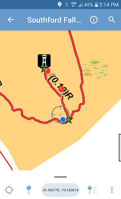
"Did I miss the turn?"
Southford Falls State Park

The map below is a portion of Sleeping Giant State Park zoomed in. This map is especially useful because it's a large park with many trails and also many steep hills and cliffs. The printed map can be hard to read, and typically doesn't show contour lines telling you where the big hills are. Viewed within Avenza, the map was much more informative. For example, it's obvious that the White Trail is going up some steep terrain while the other trails are more gentle. 
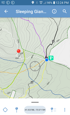
Sleeping Giant State Park


Wednesday, April 21, 2021

Birchbank Drainage Project & Bridge

Finally tackled a chronic wet and muddy part of Birchbank Trail with a combination of a bridge, rock-lined trench and causeway, perforated drainage pipe, and trail hardening with big flat rocks. The two pictures below are the exact same view.  

"After" (April 2021)

"Before" (March 2021)

This is the same location of Tom Savarese's Eagle Scout project of 2014, during which the seasonal stream was channelized and the nearby bench installed (along with other drainage work along the trail). Previously, the rocky stream fanned out and covered 30 or 40 feet of trail. What we discovered later is that water wasn't just coming down the stream channel, but was seeping out of the hill onto the trail as well. A surprising amount of mud was deposited on the trail that was formerly cobblestones (see photo below from 2015), and during the wet season that mud was a mess. Some big fallen trees didn't help, since they blocked the flow of water. 

The same spot in 2015, a year after Scout channelized the stream

Things came to a head last winter when I saw a trail runner hopping from log to log and then slipping and falling in the mud. If you had waterproof hiking boots, the spot wasn't that big of a deal, but most of the trail users in this spot do not. The Trails Committee scheduled the work party to address it, but a sudden cold snap froze everything solid. They were able to gather some rocks and pile them up in some of the wet spots, and continue digging a trench that wasn't completely frozen, but that was it. The "before" photo above was actually taken after that work party.  

"Before" (January 2021)

The photo above shows what it looked like before the January work party, looking from the opposite direction. It was a mess! The area to the left of the long log was under a few inches of water. 

"After" (April 2021)
The water seeps out of the base of the 300-ft river bluff onto a layer of hardpan it can't drain through. So for this left section, a trench was dug through the hardpan parallel to the trail, intercepting the seeping water, then the trench was filled with a perforated pipe and gravel, all wrapped in silt fabric like a burrito, and then that was covered over with dirt and leaves so it looked natural. The pipe drains into the open trench. The compacted sand and gravel from the trench was used to build up the elevation of the trail tread. And in case it still gets muddy, there are some flat stones to step on. 

Trench filled with gravel and perforated pipe

The trench that was started in January was dug much wider and deeper to accommodate floods and leaves. Water bubbles out of the hill into the trench and drains away. Parts were lined with rocks, and the compacted sand and gravel layer was used to build up the causeway.  Stepping stones were placed on the trail surface and special care was taken to place solid stepping stones where the trail crosses the trench. 

Trench and causeway

Finally a bridge was built over the stream. As always, the root footings and approaches were the hardest part. Most of the lumber was reclaimed from previous projects. This particular stream was not all that hard for a hiker to cross without a bridge, but people kept tampering with the crossing and blocking the channel while doing so. Rocks were thrown into the stream as stepping stone, but then blocked the channel. So then the water would jump the channel and flood the trail. Once the bridge was put in, all those rocks that people had put into the channel were removed, allowing for the stream to drain. Now we just hope the water doesn't get as high as the bridge, which would also obstruct the flow of the stream, but what can you do?

The new bridge  and cleared channel

The north side of the brook gets muddy, too. So a short seasonal bypass was created up the hill. We'll see how that works out before spending a lot of time trying to dewater that mudhole. 

So here it is, all put together: 

Phew!