Here's an easy two-mile loop through forest and meadows in the White Hills on Nichols Trail and the Pearmain Path, but be prepared for seasonal issues like mud, hunting, overgrowth, or snowed-in parking lot.
by Teresa Gallagher (Natural Resource Manager)
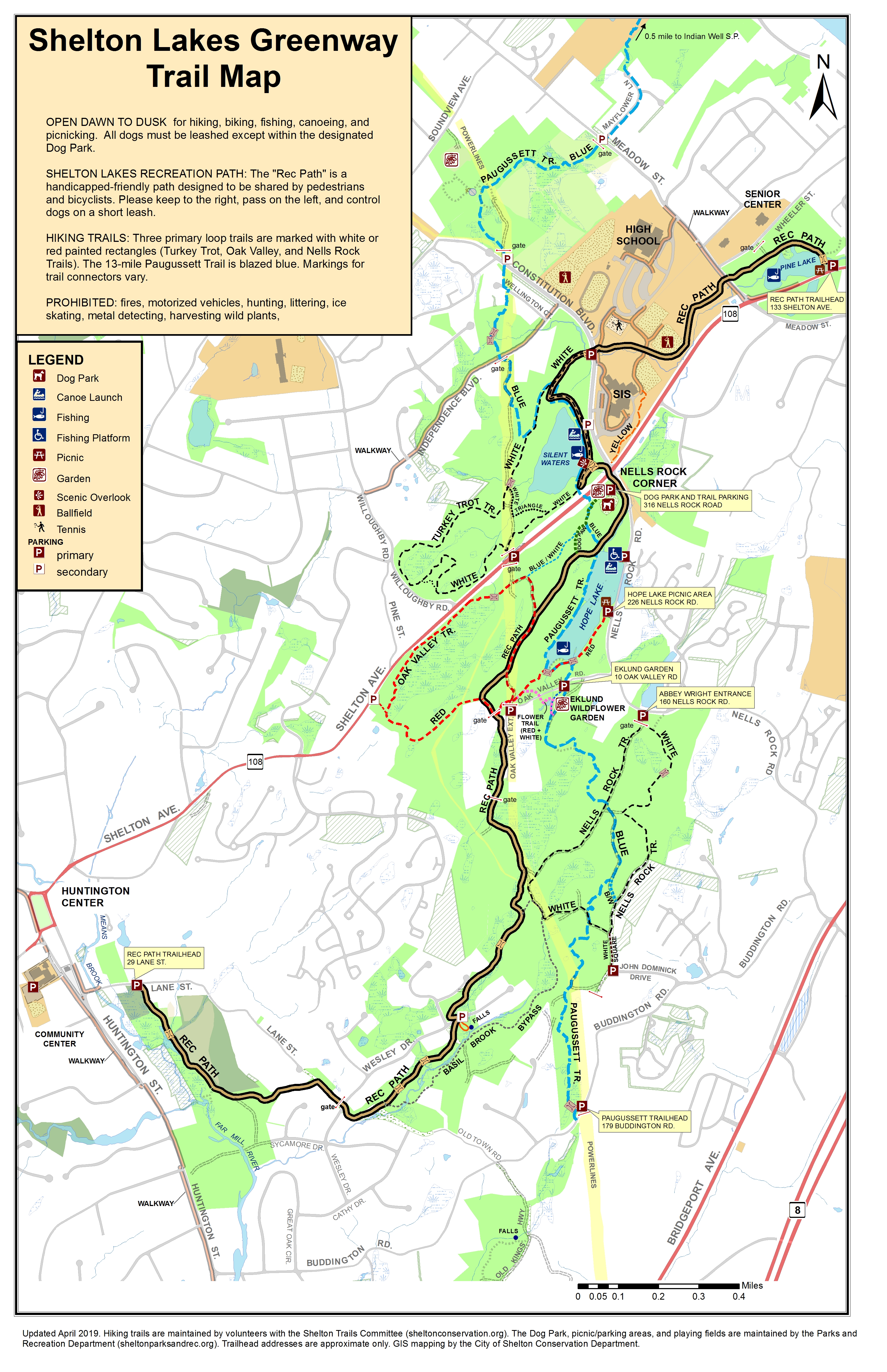
This post is part of a continuing series describing the Trails Committee members favorite jaunts along Shelton's thirty miles of trails. There are many types of trails located across the city, from the handicapped-accessible Rec Path to the rugged Paugussett Trail.
 |
| Click map to enlarge |
The outer loop at Nicholdale Farm keeps getting better and it seems like it all came together in 2020 for a high quality 2-mile loop. Click HERE for a printable map showing the full trail system. In the past year we've had improved blazing (including signs and arrows), new bogwalks over wet areas, and half of the yellow-blazed Pearmain loop was substantially relocated and is now much more interesting and scenic.
Seasonal considerations. Most of the time this hike has no issues, but before setting out be aware of the following. Winter: The parking lot may not be plowed. Spring: Wear water-proof shoes during mud season. Trail improvements are addressing the mud situation and it's getting better, but be prepared. Early Summer: In late May-June the vegetation may get away from us for a few weeks, especially near the cattle underpass. Fall: There is firearm hunting late November - December on the Pearmain Path, which crosses private property. The best times to hike the trail during hunting season are Sundays when firearm hunting is prohibited, and the middle of the day. Morning hunters have typically cleared out by 10:30 am or so, but may return in late afternoon. Wear bright colors, preferably blaze orange.
The hike: Park at the main entrance to Nicholdale Farm (gps #324 Leavenworth Road and look for the "trailhead parking" sign on Rt 110). Note that Nicholdale has a secondary signed entrance that is more visible, so be sure to pull in at the "trailhead parking" sign.
 |
| Pay attention for the dark blue markings of Nichols Trail |
Head down the steps alongside a gate and pass the big sign kiosk. You'll be doing the loop clockwise. Nichols Trail is marked with dark blue blazes and arrows. This property used to be a dairy farm, and the old farm paths and meadows are maintained by the Shelton Land Trust. Go left off the old farm road where the signs and arrows tell you, crossing a bridge with a memorial bench on either side of the brook, and continue through the forest. There's a long stretch heading south with an old stone wall to your left and some bog walks through seasonally muddy areas.
Eventually the path bends to the right and you'll come to a large boulder abutting the path and the junction of the Pearmain Path ("Boulder Junction"). Take a left and follow the yellow blazes south along an old woods road. There is firearm hunting (with landowner permission) in this section late November-December, so wear bright colors and stay on the trail or hike on Sunday. This is private property covered by a limited conservation easement. You'll cross a small stream dubbed "Abner Brook", and then the new "Pearmain Preserve" property owned by the City is just off to the left.

Just before you get to Pearmain Road, there is a 3-way intersection, with the main trail heading right and a yellow-square access trail continuing straight to Pearmain Road (the road there is unimproved and not recommended unless you have a big truck). Go right and keep following the rectangular yellow blazes. After crossing the gas pipeline, the trail enters a scenic forest with permission from the Jones Family. Please respect this private property and stay on the blazed trail.
 |
| Looking down through hemlocks at Beardsley Brook |
This is a pretty section, built in 2020. The trail, now trending north, comes to a little overlook of a stream dubbed "Beardsley Brook", then winds through some hemlocks to come back to Beardsley Brook for a bit. Right after that is Abner Brook. There is a seasonal waterfall just below the trail here. Cross the plank bridge and notice how Abner Brook is on the both the right (flowing south) and also down below on the left (flowing north). The long piece of ledge on which you are are walking has acted like a dam and blocked the flow of the brook.
After crossing Abner Brook, you are entering a new Land Trust property known as "Little Knoll." You'll know why after hiking the trail. It's not a big property, but the land down below is all water company forest, so it seems bigger. Very peaceful. Continue following the yellow blazes back across the gas pipeline and rejoin the blue-blazed Nichols Trail at the Scout Camp. Go north straight through the camp, then watch for a sharp left turn at the edge of a meadow.
 |
| Cattle underpass below Rt 110 |
The rest of Nichols Trail goes in and out of meadows and along old farm roads, with some sharps turns, so pay close attention to the blue trail markings. After awhile the trail will cross a wooden bridge over a brook and then a stone bridge over a seasonal wet spot, and cross a large meadow bringing you near Rt 110 and an access trail leading across the highway to Willis Woods and Stockmal Trail. Ignore that and head right (east) to parallel Rt 110 for the remainder of the loop. The first section is on the old Leavenworth Road before it was upgraded to a state highway. The trail then winds around the woods a bit before coming out onto a meadow that can be a bit wet in the spring, and overgrown in early summer before the crews can get to it. Just before you arrive back at the parking lot is a square tunnel under the highway. This was built as a cattle underpass when the state constructed the highway across the farm. Sometimes in early summer the tunnel is obscured by vegetation, but it does get cleared out eventually.


