 |
New Eversource towers, grading, and road at Black Rock S.P.
|
Electricity is a good thing, so Eversource is planning to replace their old towers in Shelton, including the ones at Shelton Lakes and French's Hill where we have trails. We're accustomed to work along the powerlines, but the scale of this proposal is unlike anything we've seen before. It will have major impacts on our trails, both during and after construction.
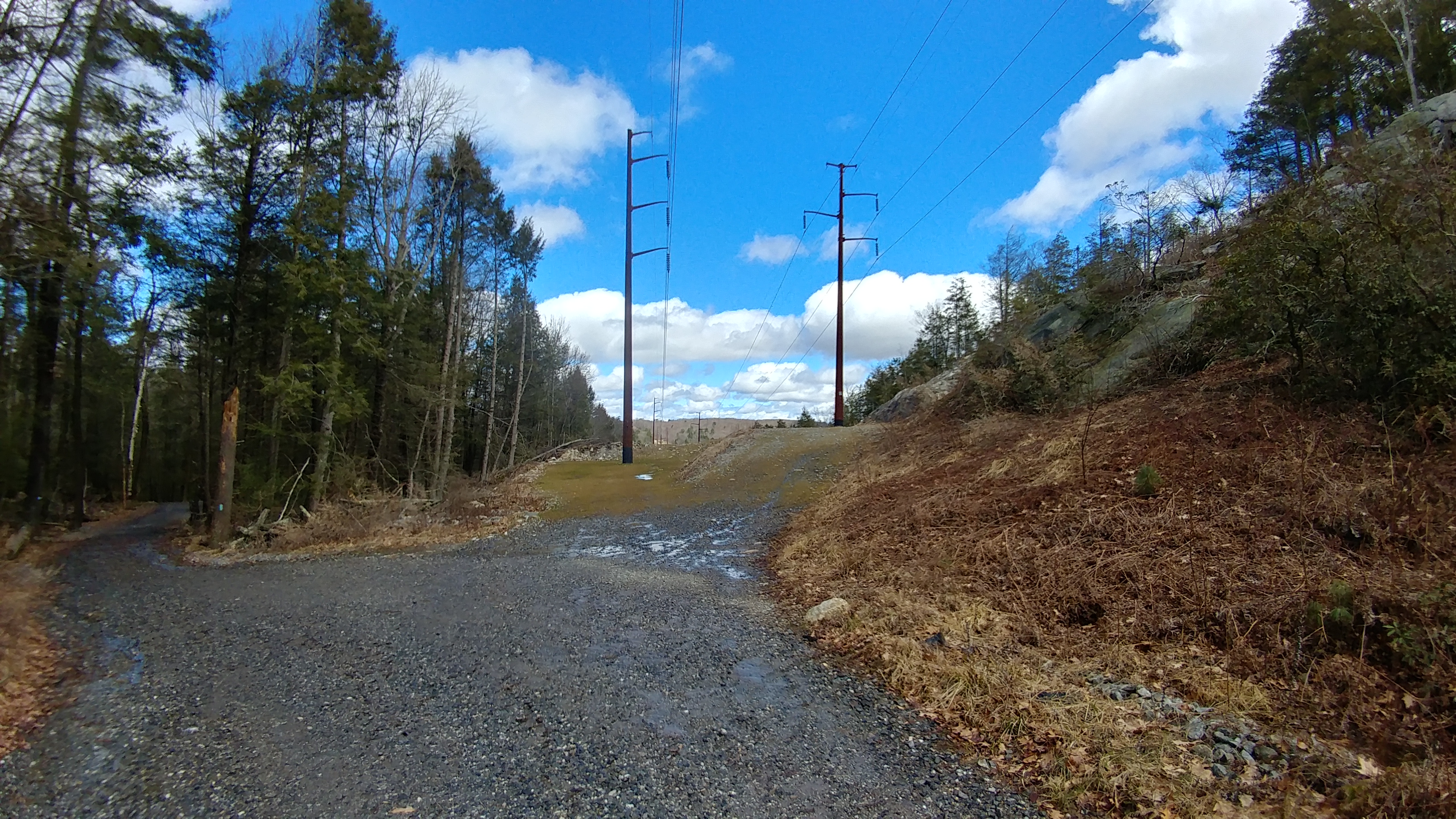
Similar Project at Black Rock State Park:We were told that the work in Shelton would be very similar to the work done last year at Black Rock State Park, which I happened to hike during construction in 2021 as part of the DEEP's Sky's the Limit challenge, following CFPA's blue-blazed Mattatuck Trail and the park's Red Trail to follow the popular loop to a scenic overlook specified in DEEP's challenge. I had some difficulties there, losing the trail due to the construction, but I'll get to that later. More important is what the long term consequences will be to the trails, so I took a drive up this spring to see what that area looks like now that construction is complete. This is what Eversource plans for Shelton Lakes.
Access Roads: Eversource plans to upgrade existing access roads and build new ones in some locations along our trails. The existing utility access roads at Shelton Lakes are mostly goat paths we have to mow. They feel like the natural ground surface even where they might not be. The new roads would be 20-foot wide graded roads covered with crushed stone.
 |
| Existing access road and Paugussett Trail |
At Black Rock State Park, crews were granted permission to use a portion of the 42-mile Mattatuck Trail that is outside of the easement area, and this is what the hiking trail looks like now:
 |
| 20' wide access road built over Mattatuck Trail |
 |
| Surface of upgraded access road, Mattatuck Trail |
In 2021, some of the blazed trees marking the hiking trail had been removed for the new road, so I only knew I was on the Mattatuck Trail by stopping to check the Avenza Map app on my phone. I then missed where the trail turned off of the access road because it was overgrown and not marked, and continued walking up the access road with trucks going by and kicking up dust. Eventually the road curved away from where the trail was supposed to be, and I realized my mistake and hunted around with trucks going by until I found the overgrown trail junction.
Revisiting the access road a year later, I found it unchanged. I was surprised that the Mattatuck Trail had not been relocated to get it off of the access road.
Tower Pads: The existing towers in Shelton do not have pads. They were plunked down on the existing grade for the most part, with four concrete footings providing stability. The new system calls for large "pads" to be graded out. At Shelton Lakes, the pads will be as wide as the clearing. Where there is ledge and hills, those are to eliminated to make for the level pad. In places, the pad will be on two levels. This is what that looks like at Black Rock, which is also rocky and hilly like Shelton Lakes:
 |
| Ledge was pulled down and the area graded flat for a pad |
 |
| Access road curving around a two-level pad |
 |
| Rock cut with pad on top, road and 2nd level pad on bottom |
 |
| Two-level pad |
 |
Access Road/Mattatuck Trail coming in from left;
two-tier pad in center |
Imagining Shelton Lakes after construction: Compare those new graded pads at Black Rock State Park to the more natural terrain around Shelton's existing towers. The old towers were molded to the existing grade with minimal disruption of the terrain. In the future, instead of molding the towers to the landscape, the landscape will be altered for the towers. Heavier installation equipment also requires better access roads than was needed in the past.
 |
| Existing tower at Nells Rock Trail |
 |
| Existing tower at Nells Rock Trail |
The Iroquois Gas Pipeline is another complication. In the picture below, the existing access road travels along the pipeline, as does Nells Rock Trail. This is outside of the Eversource right-of-way. Any kind of construction near a major pipeline increases red tape. Therefore, Eversource plans to build a second parallel road between the two sets of towers in the photo. Some of this road will be in wetlands, so it will be on a temporary heavy timber matt that will be removed. The two ridge tops that anchor the existing towers (and Nells Rock Trail) will be leveled out for new pads. We don't have the details, yet, but have asked Eversource for a grading plan.
Would it make sense to relocate Nells Rock Trail off of the powerlines? The trail route was a lazy one utilizing existing woods roads that connected to the powerline road. Maybe there is a better way. Stay tuned.
In the meantime, the Shelton Trails Committee is hoping to minimize disruption to the landscape where we have trails that cannot be relocated.


No comments:
Post a Comment