 |
| Reroutes circled in blue and red |
A couple of modest reroutes at Birchbank are redirecting hikers off of an old eroding road bed where footing can be difficult, especially in the fall. On the map above, the area circled in blue was just completed while the section circled in red is under construction. The old road is shown as a double-dashed line.
This is an area where waterbars would not have worked because the land needs to drop off on one side so the water can be channeled off of the trail. The old road is too deeply eroded (as much as three feet deep) with the land rising on both sides. It's essentially a long gully.
 |
| Bits of blue and yellow from a former blaze |
Much of the erosion was caused by ATVs and dirt bikes. At one point many years ago, CFPA blazed the old road blue with a yellow dot in the center and maintained it as part of the state-wide Blue-Blazed Trail system. This was back when the property was owned by the Bridgeport Hydraulic Company. But the trail managers grew tired of the ATVs and CFPA finally abandoned the trail. If you look closely, you may find some old blue/yellow blaze remnants. We don't know when that was, but it was prior to 1998 when the city purchased the property.
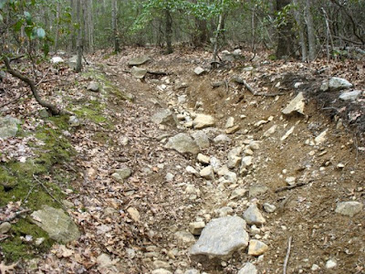 |
| Not fun to walk on or to look at |
After the City took title, the old road was blazed white and named Birchbank Trail, but it soon became apparent that parts of the old road were treacherous to walk on, especially in the fall with fresh leaves hiding loose cobbles underneath. Several years ago, a section of the trail was moved off the old road and now follows Upper White Hills Brook. This bypassed the worst spot, but not all the bad spots.
 |
| Top of the new reroute, where it connects with the existing trail |
 |
| Rock slope where a big wild animal should live |
 |
| Grassy area, top half of the reroute, |
Besides getting the trail off off the eroded gully with a more sustainable route, a major goal was to make the trail more scenic. Heading down the hill, the first part of the broad new "S-curve" takes hikers to a bowl-like feature at the bottom of a rock face before heading through a flat grassy area at the top of the steep slope.
 |
| View of Upper White Hills Brook at the "chute" |
After crossing the old road again for the second half of the "S-curve", the new trail route heads down to an overlook of Upper White Hill Brook at the water chute and slide. If there's been rain, hikers will hear the sound of running water as they approach, and can wander on down the hill if they want to leave the trail and explore. Otherwise, the trail continues to rejoin the old road through an area where students from Shelton High School did a lot of work benching in the trail last year. This reroute actually started as an overflow project for the students in case they finished up the main job, which was the reroute of the Paugussett Trail. We had a good turn out, so the Birchbank reroute was started.
 |
| Lower junction with the old road |
The last photo was taken at the lower junction with the old road, looking back up the trail. The new trail goes off to the right. This is the spot the students benched in last year. The old road (and old white trail) goes off to the left, now just an old gully that no one needs to walk on. If people (including ATVs and hikers) will stay off of it for awhile and let it fill in with leaves and sticks, the erosion should slow down substantially.


No comments:
Post a Comment