 |
| Digging in the south end |
We had 34 people at the Sunday work party to start clearing the new Curtiss Brook Connector (that's the working name of the trail, not sure what it will be called officially), many of them high school students. We now have a 'rough draft' of a trail. It still needs more work, but it can be followed.
Much of the work was picking up decades of litter, including about 25 bags of litter, a pool ladder, car parts, wire, old garbage cans, and other assorted materials (these were hauled away the next day by the Highways & Bridges Department).
 |
| Some of the crew before they got dirty |
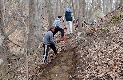
The other big task for the day was digging the trail into the side of the hill. The north and south end each needed lots of digging, while the center section was in mostly good shape. The south end (near Pine Lake) was harder digging and steeper, but had less garbage.
Mark Vollaro, Ray Hansen, and Teresa Gallagher had done some preliminary work before the work party, including chainsawing and raking out the tread. Terry Gallagher put together a big list of all the equipment that would be needed and staked out a section of parking lot ahead of time. This allowed the volunteers to get right to work.
 |
Digging in the south end, looking towards
Pine Lake |
 |
| The center section didn't need much work |
 |
| The north end |
The north end (towards downtown Shelton) was at the base of a stone retaining wall holding up the state highway, and it was impossible to dig without hitting layers of old cans, bottle, asphalt, wire, etc. Aiden Zitnay managed to finally pull out a big coil of wire that was buried in the trail, and then found an old horse shoe. This section looks like it might be part of the old Shelton Turnpike from the 1800s, so that was pretty cool.
 |
Aiden managed to pull a
big coil of wire out of the ground |
The other issue with the north end was all the landscaping debris the homeowners across the street have been dumping over the wall.
 |
The north end starts at the base of the Rt 108
retaining wall. |
 |
The crew pulled out about 25 bags of litter, car parts,
a pool ladder, garbage cans, and other stuff |
 |
| The last of the crew |
There is still more litter in there, especially down in the brook and up the opposite side, if anyone is looking for a challenge. And there is more digging to do. But it's getting there!


.jpg)


