People like trail signs and have been asking for more signage since the 1990s.
It's one of those things that's great in principle, but classic signs are time consuming and in the past have been prone to vandalism. Over the last two years, we installed some routered signs at the Rec Path trail junctions and a few other places, and so far those signs have all survived. So it seemed safe to add a few more, and with the large number of Covid hikers this year, the signs were needed more than ever. There were a lot of new people on the trails not accustomed to dealing with trail blazes and maps. So over the hiking season, signs were added a few at a time. The 2020 signs tally now stands at:
- 32 hand-routered signs
- 1 raised-relief header sign for the Birchbank kiosk
- several turn arrows
- 16 hand-painted (not routered) signs at Indian Well
 |
Birchbank's Chimney Junction
|
People still cannot rely on signs to tell them where to go. Trail users have an obligation to be prepared and bring a map (don't rely on cell phones when on an unfamiliar trail). But we've learned that many trail users either have no official map and no clear idea of the trail system (and are sometimes using apps like AllTrails, which is both confusing and inaccurate in Shelton), or they might be really familiar with one small part of a trail system (like the Rec Path) and have no idea what the trail junctions are or where the side trails lead.
 |
The blue/white Birchbank Connector is more inviting now
|
Also, most people don't know the names of the trails. When the Trails Committee members talk about the trails, they typically use the trail name, not the blaze color. We don't say "the red trail at Shelton Lakes." We say "Oak Valley Trail." It's always a little sad when people walk on a trail several times a week for years and don't know the name of the trail. Then again, how would they know the name of the trail unless it's on a sign? The trail names are on the maps, but people tend not to look at the maps. Anyway, the trail signs let people know the names of the trails.
 |
| Kiosk header sign - the hardest one of all |
Mileage was added to some of the signs. We heard of some hikers on the Rec Path near Lane Street thinking they were near the Dog Park because the Rec Path goes past the Dog Park. It does, a few miles down the trail (the Rec Path is 4.2 miles long). Mileage on a couple Paugussett Trail signs was also added for awareness of how long the blue trail is (13 miles) and how it connects major park areas. At the Birchbank's "Chimney Junction", for example, people walking on Birchbank Trail encounter a mileage sign for the Paugussett that shows they are half way between Indian Well and Webb Mountain. People like that sort of thing. And on the Rec Path near Silent Waters, a Paugussett turn sign lists the mileage to Indian Well.
 |
For people who think they are near the Dog Park
|
 |
The Rec Path got several new signs at sharp turns
|
The signs are made from cedar, and routered by hand. Sure, there are CNC machines out there that can make perfect letters, but we strive for "tastefully rustic." Hand-routered lettering is classic for trail signs and has more character than machine lettering.
One of the trickiest parts of the process is transferring the lettering onto the boards. It sounds so simple and yet can be frustratingly difficult to pull off. A craft projector is used to beam an image of the lettering onto the boards, which is traced onto the wood with a pencil. The routering is loud and dusty, but goes pretty quickly once all the correct router bits have been figured out. It's the painting that takes the most time.
 |
Cedar boards and projector
|
Then it's time for installation. To discourage vandalism and give the weak cedar wood more strength, a backer board is used. Reclaimed trail bridge deck boards are used. The back board is bolted to a tree or 4x4 post, and then the cedar sign screwed to the backer board with a variety of hardware. The signs most prone to vandalism may be installed very high on a tree, which requires carrying a ladder down the trail.
 |
| This used to be a cedar tree. |
What got signed? Trail junctions, for the most part. Confusing bends in the Rec Path. And there were some trail entrances as well. Boehm Pond Trails, Little Pond Trail, and the Senior Center entrance to the Rec Path were all signed.
 |
| Voted the most confusing trail junction |
Turkey Trot Trail along the powerlines was said to be the most confusing junction. As it happens, while heading out to install signs there, a hiker came up asking for directions.
 |
| People didn't even know there was a trail here |
Little Pond Trail was our least know trail. During installation of an entrance sign, neighbors walking past the trailhead stopped to ask if that was a trail. Yes, it is, and the sign proves it.
 |
| Side trail off the Rec Path gets some advertisement |
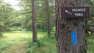
Nichols Trail at Nicholdale got a a few signs and a slew of arrows because that trail has some sharp turns in meadow areas that can be hard to spot amongst all the other mowed paths.
 |
Help for Nichols Trail
|
 |
| This spot used to be pretty confusing and easy to miss |
The Pearmain Path at Nichols Trail junction got some clarity, as well as a sign cautioning people to wear bright colors during hunting season.
 |
The Pearmain Path at Nichols Trail
|
Early in the season, a bunch of arrow signs were hand-painted for Indian Well. These were not routered because the trail was deemed highly prone to vandalism. But the Covid crowds were wandering up and down the trails asking, "Where are the falls? Where are the falls?" Especially since the falls parking area was shut down during bridge reconstruction. These signs were a big help.
 |
| Signs for Indian Well |
Hopefully the new 2020 trail signs will last ten or twenty years. Signs are traditionally routered so they are still legible after the paint wears off.


No comments:
Post a Comment