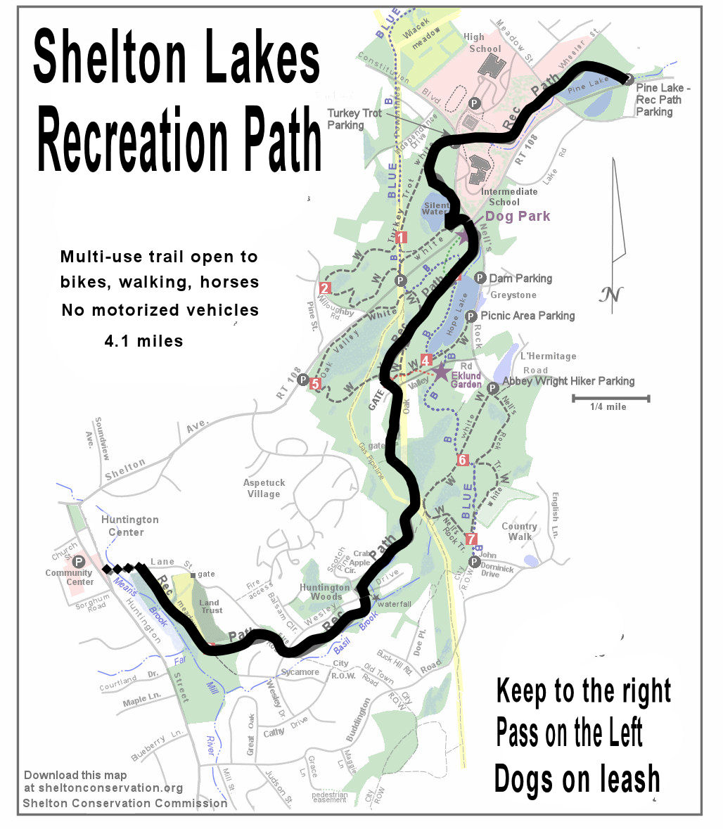
SUMMARY: The Shelton Lakes Recreation Path is the easiest of all our trails and is handicapped-friendly. It connects the downtown area with Huntington Center, passing three scenic reservoirs along the way. Total length is four miles one way, which may be hiked in increments, or you may spot a car at the end of the trail. The path has a crushed stone surface and is marked with granite posts at road crossings. Dogs are allowed - please clean up after your pets and they MUST be leashed on the Rec Path no matter how well behaved due to bike traffic. This is a shared trail, so please be sure to keep to the right and pass on the left. There are restaurants in Huntington Center near the end of the path.
Address numbers are approximate for use in gps devices. Click links to view location on map.
PARKING: There are multiple places to park along the Rec Path, including:
Pine Lake Trailhead: #130 Shelton Avenue (Rt 108) east of Meadow Street. Ample parking.
Shelton Dog Park #316 Nells Rock Road, near junction with Shelton Avenue. Parking gets crowded at peak times.
Wesley Drive, upper crossing, #89 Wesley Drive, north of Scotch Pine Drive. On-street parking. Please do not block sight lines between people using the cross walk and drivers.
Lane Street Trailhead #29 Lane Street, off of Huntington Road. LIMITED PARKING. Additional parking is available at the Community Center on Church Street.
SEASONAL PORTOLET: Located at the Dog Park, which is 1.25 mile from the Pine Lake Trailhead.
TRAIL MAP: Please be sure to bring along a map, available HERE.
BLAZE COLOR: None - doesn't need it. Although there are some old yellow blazes here and there.
HIKE DESCRIPTION: (This description assumes you are parking at the Pine Lake Trailhead on Shelton Avenue and walking the four miles to Lane Street). At Pine Lake, notice the granite posts before you walk across the pedestrian bridge over the dam. These posts mark the road crossings along the Rec Path - this is the only trail without blazes painted on the trees.
This is the first of the three reservoirs you will see along the way that stored water for fire suppression downtown. Follow the wide gravel path through the pines along the backside of the reservoir, cross Meadow Street, and the path is now paved as it heads gradually up the hill towards the school campus area. Pass a playing field to the right and intersect a paved school path, staying straight as the path turns back to gravel. You are in between Shelton High School and Shelton Intermediate School, coming to a crosswalk on Constitution Blvd North, where there is a small parking area and sign kiosk. This is the trailhead parking for Turkey Trot Trail, another one of the Marathon Hikes.
Continue into the woods along the gravel path, which curves sharply left to follow the top of an old dam from the 1800s. You won't see water here because most of the water from this reservoir was drained, but a hundred years ago you would have been walking along the shoreline. The total length of this dam, which is in two parts, is 1/3 mile. Wow! The second part of the dam takes you over a bridge with nice views of Silent Waters. This is a very shallow pond that is home to a lot of wildlife, such as wood ducks. The dead trees in the shallow water are from when the water level was raised during construction of the Shelton Intermediate School. Continuing on, at the end of the dam be sure to take a sharp left to stay on the Rec Path, and follow that out to the intersection of Shelton Ave and Const. Blvd North/Nells Rock Road. Use the crosswalk and walk button to cross Shelton Ave towards the Dog Park. You are now 1.25 miles down the trail.
Continue along the gravel path gradually up the hill, now on the back side of Hope Lake, also called Nells Rock Reservoir. The trail will link up with Oak Valley Trail (blazed red) for a short time, passing under the big powerlines, then turn left at an old woods road and come to a big green gate, where Oak Valley Trail and the Flower Path go left off of the old gate. Walk around the gate and continue on the gravel path, quickly crossing one driveway and then another driveway and gate further on.
Now you will be following the powerline corridor for a bit before the gravel trail takes a right turn back into the woods, winding around some wetlands and "Lizard Head Rock" before crossing Wesley Drive for the first time ("Upper Wesley Crossing"). It's all downhill from here. You will cross over two wooden bridges then cross Wesley Drive for the second time and head past the black gates. This section of the Rec Path also serves as an emergency access road for Lane Street and Aspetuck Village. The path turns sharply left off of the emergency access road to slide between houses, then down the hill through the trees, coming out at the Lane Street Meadow owned by the Shelton Land Trust. There is an unmarked side trail on the left leading to the spot where Means Brook and the Far Mill River join. Continuing on the Rec Path walking along the meadow, cross the boardwalk built entirely by volunteers, and cross through a smaller meadow before heading back into the trees to finally arrive at Lane Street, marked by a sign kiosk. This is the end of the trail. If you go left on Lane Street you will soon come to Huntington Street near the Fire Station in Huntington Station. There are multiple eating establishments nearby.
Trail construction & maintenance in and around Shelton, Connecticut. Nature and greenway information.

Contributors
Followers


Shelton Trails Links
- Trails Work Reporting Form
- Agendas & Minutes
- Shelton Conservation Commission
- Eklund Native Species Garden
- CFPA (CT Forest & Parks Assoc.)
- Shelton Anti-Litter Committee
- Shelton Land Conservation Trust
- In The Field
- Conn. Chapter - New England Mountain Biking Assoc.
- Cool Trail Solutions - American Trails
- Housatonic Valley Association
- Nutmeg Chapter of Trout Unlimited
No comments:
Post a Comment