Here's a super brief history of our hiking trails in Shelton, starting with the oldest trails (trails that no longer exist are not included):
- The Bluff Walk at Riverview Park (early 1900s): The park was donated to the City in the late 1800s by the Shelton Canal Company, and by 1919 there was a carriage path on the south side of the park that is now part of the Bluff Walk. A 1934 aerial clearly shows the existing route of the entire trail.

1934 aerial of Riverview park shows the park road and trails
(click photo to enlarge) - The Paugussett Trail (1930s): Created by the Connecticut Forest & Park Association (CFPA). The 1937 CFPA Walk Book describes the trail from Roosevelt Forest in Stratford through Indian Well and ending at what is now Birchbank with an access trail leading down the hill towards the Irving Boy Scout Camp (this access trail was the proto Birchbank Trail). A 1940 map shows the trail completed north to Lake Zoar. The Paugussett south of Indian Well was abandoned in the 1980s after Aspetuck Village and other new developments blocked the trail. The City of Shelton re-established the trail south to Buddington Road (formally recognized by CFPA 2013). There have been many substantial relocations of the trail over the years.
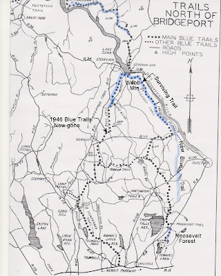
1946 map showing CFPA trails
(blue highlight shows location of current trails) - Birchbank Trail (1930s) began as a blue/yellow CFPA access trail across water company lands to the Paugussett Trail (0.7 mi.), but after many years was abandoned by CFPA in the 1990s due to chronic ATV damage. After purchasing the property, the City of Shelton re-established the trail as an expanded white-blazed lollipop-loop (2008), following old roads and neighborhood trails. A number of relocations due to erosion have occurred.
- Tahmore Trail (c.1987) was created by the Shelton Land Trust and/or CFPA, and was shown in the 1993 CFPA Walk Book as a blue/yellow side loop of the Paugussett Trail. A major reroute occurred in 2020.
- Oak Valley Trail (1994/1995): This was the first of the modern City of Shelton trails, created under the auspices of the Conservation Commission across what was then known as "Stewart Woods" at Hope Lake. It was originally blazed white, but was changed to red in 2019.
- Nells Rock Trail (1996): The east half of the loop was formally blazed and mapped on the old Abbey Wright property that was originally acquired to be used as a landfill. The loop was extended some time after 2006 when additional property was acquired.

Trail Map from 1996 - Dominick Trail (1997): This orange-blazed trail first connected J. Dominick Drive (off of Buddington Road) to Nells Rock Trail, then was extended to the back side of Hope Lake and finally to Shelton Ave at the powerlines. Most of the trail was eventually converted to the blue-blazed Paugussett Trail. The south end became a white square access trail, Nells Rock Trail, and a short blue/white connector, while the north end near the Dog Park was reblazed blue/white.
1997: The Shelton Trails Committee was formed, and the Shelton Lakes Open Space purchase referendum was passed, in 1997. The City would take title to 471 acres for $7 million, including three reservoirs at Shelton Lakes, and the Birchbank property. - Shelton Lakes Recreaton Path (1998 to 2012): Years of planning and the acquisition of Shelton Lakes allowed clearing to begin in 1998. The path was completed in sections over the years as funding and land acquisitions allowed. The paved section was the first completed (2001) due to funding secured by Dick Belden. The Pine Lake bridge was installed in 2002 and the Lane Street boardwalk was constructed by volunteers in 2006.
- Gristmill Trail (2000): This trail off of Mill Street crosses one of the properties purchased from the water company in 1998.
- Turkey Trot Trail (2001): This loop was created as a 5K track for the school Cross-Country team. It crosses the Shelton Lake property purchased by the water company.
- Boehm Pond Trails (2008): This trail system is located off of Far Mill Street and Winthrop Woods Road.
- Nichols Trail (2010): Originally known as the "Perimeter Trail" at Nicholdale Farm, this trail was created by Scout Joe Delgado for the Shelton Land Trust. The Trails Committee helps maintain the trail because it provides access to the City's Pearmain Path.
- Dog Paw Path (c. 2012): Blazed with little dog prints, this trail leads from the Dog Park (behind the big barn) to the Rec Path
- Flower Path (2012): This connector at Shelton Lakes leads from the Rec Path to Eklund Garden.
- SIS Connector (2014): This yellow-blazed connector runs along Shelton Ave next to the Intermediate school.
- Little Pond Trail (2014): This short trail off of Beech Tree Hill Road was created by Luke Claire for his Eagle Scout project.
- The Pearmain Path (2014/2020): The first version of this trail was completed in 2014 to comply with an old DEEP grant requirement. A return loop through the private Jones property & Land Trust "Little Knoll" property was completed in 2020.
- Basil Brook Bypass (2015): This trail at Huntington Woods (Shelton Lakes) allowed for loop options off the Rec Path and for mountain bikes to "bypass" the Rec Path.
- Stockmal & Willis Trails (2018): Previous trails on these lands had been created by Boy Scouts via the Land Trust, but became overgrown and abandoned, so new trails were created. Stockmal Trail was required under an old DEEP grant.
- Indian Well Beech Cut-Off Trail (2020): This blue/red trail provides quicker and easier access to the Falls from the Beech, and can be used to make a loop.
- French's Hill (2022): This loop trail system is off of East Village Road and is required under a DEEP grant.
- Burritt's Bypass (2022): This blue/green trail at Birchbank offers a safer way to descend a rocky slope ("Burritt's Rocks") while northbound on the Paugussett.
- Woodsend Trail (2023): This one-mile trail was created thru Housatonic Woods Preserve after an open space purchase allowed for public parking. The new trail passes over a rock face above Rt 110 and Indian Well, and allows for a lollipop loop when combined with the Paugussett Trail.
- Curtiss Brook Connector (2025): This trail, which is still under construction, will allow pedestrians to get off a narrow section of Rt 108 when trying to access the Rec Path at Pine Lake.


No comments:
Post a Comment