 |
| Cell phone screenshot: Blue dot marked the current location |
Did you know that with a free phone app such as the popular Avenza, you can see your current location on some of our official trail maps? The maps this should work on are:
*Shelton Lakes
*Tahmore/Indian Well
*Means Brook (Nicholdale & Willis Woods)
The reason it works for these particular maps is because they were created using the City's GIS system, which encodes gps location information into the map as it is saved as a pdf file. Our other trail maps are simply pictures, so they won't work in Avenza.
Our state parks and forest maps are mostly available for this purpose, as are a few other random locations around the state, such as some land trust maps. The above photo is a cell phone screen shot showing our Shelton Lake trail map, zoomed in. The blue dot was my current location at the time.
Here's how you do it:
1. Download an app such as Avenza (this seems to be the most popular, and it's free).
2. To view State Park maps, search for the park by name in the Avenza Store (the maps are free, but you still find them in the Avenza store).
3. To view Shelton maps, you will need to download them to your phone, since they are not in the Avenza Store, and then open the map using Avenza. Every phone is different, so it's hard to give exact directions. From your phone's browser, visit http://sheltonconservation.org/recreation/shelton_trails.html and select the map you want. Then look for a way to download and open the map using Avenza. If your phone automatically opens the map in a pdf reader, click the reader menu and look for "open as". You might also download the map onto your PC and email it to yourself as an attachment, open the email in your phone, then when you click the attachment you may be prompted for what app to use.
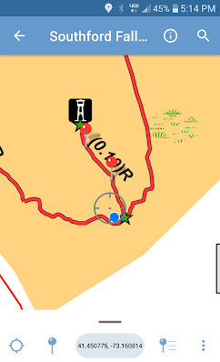
Once you have the map open in Avenza, you can leave pushpin marks or have the app trace your route. This is handy for marking the location of a fallen tree, or to follow your progress. The screenshot of Southford Falls State Park map below shows the point at which I thought I must have passed the trail to the tower and was checking the Avenza map to see if that was the case ...but the trail junction was right up ahead.
 |
| "Did I miss the turn?" Southford Falls State Park |
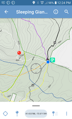
The map below is a portion of Sleeping Giant State Park zoomed in. This map is especially useful because it's a large park with many trails and also many steep hills and cliffs. The printed map can be hard to read, and typically doesn't show contour lines telling you where the big hills are. Viewed within Avenza, the map was much more informative. For example, it's obvious that the White Trail is going up some steep terrain while the other trails are more gentle.


No comments:
Post a Comment