Thursday, December 15, 2022

RIP Boehm Beaver Pond

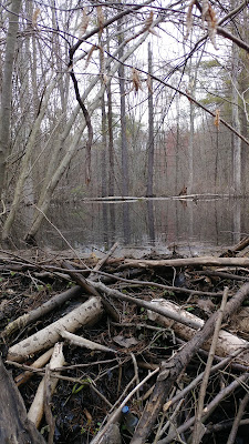
The beaver pond 

Park users had really been enjoying the trailside beaver pond off Winthrop Woods Road until someone -- we don't know who -- came in with heavy equipment and ripped it apart. 
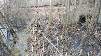
The beaver dam before it was destroyed

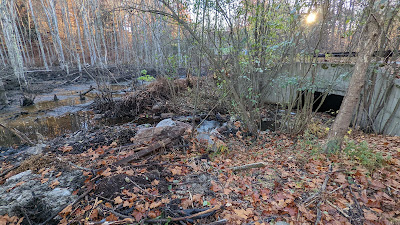
After the dam was breached and the pond drained

Hikers had been sharing photos of the beaver, along with other pond animals like muskrat, ducks, and even some visiting otter. Beaver ponds make great habitat for a number of species. The beaver pond was an enlargement of Boehm Pond, which is completely surrounded by protected conservation lands. There were no reports of human structures being impacted, so the beaver seemed OK. Some people did call to complain that the beaver were killing the trees in the open space, and they thought it was an eyesore, but since it's conservation land, and beaver ponds are natural and beneficial to wildlife, no action was warranted. 

Boehm Pond Beaver Dam (2020)

Nevertheless, someone dismantled the guardrail on Winthrop Woods Road and brought in heavy equipment to rip apart the beaver dam, take out trees, and move large rocks along the shore. People in the neighborhood assumed City crews had done the work, but no one at the City authorized or knows of any crews having done this. 

Otter slide tracks on the beaver pond

Normally, beaver would immediately rebuild the dam, but it hasn't happened. That means the beaver died or moved on. We did receive a report of one beaver hit by a car over the summer.  What happened to the others? 


The dam breach

The drained pond is pretty ugly for the time being, but it should green up quickly next year. Lots of sunlight will reach the enriched ground, and a new kind of habitat will be created. This would have been the normal end for the beaver cycle, but it happened faster than normal and old beaver dams normally retain water long after the beaver have left, so the beaver pond is longer lasting. 

If anyone has information on what happened to the beaver dam, email conservation@cityofshelton.org. 

Saturday, December 10, 2022

You Shall Not Pass

There was a big turn-out to help clean up the Old Trails Barn and move stuff over to the new Trails Barn.  It was a brisk morning and by brisk I mean cold.  So we got to it quickly.  Folks broke up into multiple work parties and started tackling various tasks to get the blood moving.

Some when to clear out the old woodpile by the Dog Park fence, and move it into the old Barn.  Some moved some stuff to from the Old Barn to the New Barn, some went to fix broken railings at the Silent Waters Dam, some started shoveling the pile of processed stone before it froze in place, and some started driving the stone around and dumping it off. 

Val & Bill fixed the busted rails on the RecPath fence at Silent Waters (again).  A tree had come down and smashed the rails, and the Trails volunteers fixed this hazardous spot.  There may be other hazardous spots out there along the trails, but we repaired this one today before the ground froze.


The Silent Waters Canoe Launch on Constitution Blvd North needed some tread repairs due to erosion and tree roots.  So while people were moving stone and barn contents, others were dropping off crushed stone to improve things for next spring.

It took at least 4 loads (surprisingly) but we got the canoe drop off ready for Spring.

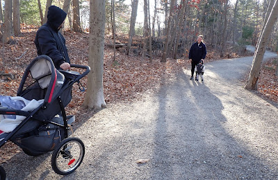
 There were some RecPath customers that came by as we were working.

This little guy seemed a bit bewildered by the whole process, but who knows; he could be on the Trails Committee some day, probably also fixing up the RecPath and canoe launch.

The ramp down to the lake was fixed up.  Now all we have to do is fix up the stones along the launch.  That may wait until the weather is warmer at this point.

Others were moving stuff between the barns, and loading stuff into the Gator to get hauled up the RecPath from the Dog Park.  That material will get moved around to repair erosion when it defrosts.  Thanks to the City of Shelton crews for dropping the crushed stone mix off at the parking lot.

Here's Graham doing his "You Shall Not Pass" pose from Monty Python and the Holy Grail movie.  In reality, he's just finished feathering out the drop off at the bridge abutments so our handicapped - accessible path is actually handicapped-accessible for folks who want to enjoy the woods without an aggravating 3/4" jump at the bridge.  And it's also more enjoyable for folks that walk, ride bikes, push baby strollers, etc.  It may sound dumb, but it's the little things that matter sometimes. 

Thanks to everyone who came out: Bill, Val, Mark, Mike, Ralph, Ralph, Ted, Graham, Mary, Mike, Terry, Annie, Bob, Sam and anyone else we missed.   A lot of seasonal tasks got done around the Trails Barns and RecPath at Shelton Lakes.

Sunday, December 4, 2022

Round Hill Road Roundup

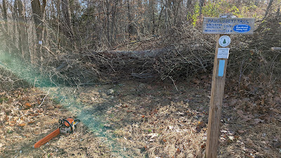
Following risking my life getting supplies for Christmas Cookies at Shop Rite on Sunday I headed out for some trail work.  Went out to cut up what I thought were some easy blowdowns on the Paugussett Trail south of Round Hill Road.  Sharpened my saw, filed it with gas and bar oil, drove up to the site, and what did I find.

A great big old 24" birch tree smothered with vines, briars, poison ivy, you name it, fully across the trail not 20 feet behind the trailhead.  I just had to laugh, possibly sob, and said this is going to be an interesting day.  A nearby neighbor heard me and came over to say that this had come down in the storm last night.  I asked if it made any noise, and that was a big Oh Yah.

So, carting my gear I hoofed it back toward Birchbank Mtn. to find the other blowdowns that were on our To Do List.  I came across some new blowdowns too, got to a good stopping point, turned around and started working my way back to Round Hill Road.

 
Practiced my Notch-Bucking techniques from the CFPA class on some old dead ash trees along the trail.  The blow downs were all ash and birch trees.
 

Then roll the logs out of the way.

Rinse and Repeat.  Here's a birch tree that came down recently and the top dropped across the trail behind it.

Cleared that all out and the original trail tread is restored.

The top notch is on the right (rolled away from me - on purpose), and the birch shows the "nibbling" cuts to take out the hinge

Cleared out a bunch of blowdowns and getting back to the big one at Round Hill Road.  Who rolled up at that time but Mark Vollaro (fabulous timing).  We took off the vines, briars, and whatnot, so we could see what to cut.

Mark was game and started dropping the log.  We tried to make sure it didn't bounce funny off the rocks.

But Mark brought it down with no crushed toes.

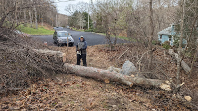
Here's mark at the end of the job.  We left a narrow notch to keep out the ATVs.  We stood back to admire our handiwork.

A right on cue a southbound hiker came through to enjoy the newly cleared trail.  Timing is everything today.  This stretch of the Paugussett Trail is now clear for the public to enjoy.

Saturday, December 3, 2022

Fixing an Old Rake, Again

Fall & Winter are a good times to fix busted tools.  A while back one of our old bow front rake heads was pulled from the land of broken toys box.  The handle was broken off just below the ferrule, and it seemed to ask if we should just junk this or what.


The old bow head rake, after cleaning.  It looked like it had potential.  This may have been a donation, or a pick up at the dump.

I looked a little closer and remembered that this was an old rake that was fixed up in the past by Rick Swanson.  This had been repaired once before when the rake head bow had rusted out.  Rick had fixed that by welding the head to the ferrule and it was jammed back on the old handle and put back into service.  That old handle finally gave up the ghost a couple of years ago, and left us with another repair.


So, next steps were to cut off the remains of the broken handle, grind off one head of the rivet holding the head to the handle stump, knock out the old rivet (using a punch or nail), wire brushing the rusty rake head, clean out the remains of the old wooden handle from the socket, and gave it a little Rustoleum love.

In the early years of the Shelton Trails Committee we got a lot of tools through donations, dump finds, or neighborhood tag sales.  We're still cheap Yankees whenever we can. 

Fuzzy picture of the cleaned-out-ferrule.  

Helpful Trail Tip: A masonry drill bit works well to take out the old handle without getting the a wood drill bit dulled up inside of the metal ferrule.

Next:  Getting and shaping the handle.

1. Skip Home Depot or Lowe's, and find an ACE Hardware store, or something similar, to get a replacement handle.  The pickings for a quality ash handle are much better at a small hardware store that caters to contractors.  Be fussy, get the grain to go perpendicular to the handle with no weird curves.  It will make the handle stronger in the future when volunteers beat on it.

2.  Shape the end of the handle to match the ferrule.  Do a trial and error pushing the handle into the ferrule and twisting it to see where it rubs.

3,  In this case we used a spoke shave and rasp to shape the handle end.  You can also use sandpaper or a file depending on what you have available.  Use whatever you have to do the job.  Just take your time and do not rush it.  Try to avoid a sloppy fit.  It'll make for a stronger rake in the long run.

After getting everything so it was a tight fit, we added a little epoxy and banged everything together.  Next day, we drilled out a hole through the handle for the new rivet, held the replacement shovel rivet in pliers, heated the end up red hot with a propane torch, shoved the rivet through the handle, placed the rake ferrule on a vise to act as an anvil, and formed a tight domed rivet with a ball peen hammer.  Lots of repeated hammer blows to shape the rivet head.

Shovel rivets are tough to come by these days.  Some are attached to replacement handles in the store, but you often have to scrounge for them.  In a pinch use a large nail, cut it off  a bit above the ferrule, heat it with a torch and then bang it into a tight dome with a ball peen hammer.

Historical Rake Note:  Rick and Madeline Swanson were great neighbors.  Rick worked on cars and was a true artist when it came to body work and painting.  He was also a good neighbor (and so was Madeline), I think he worked on every car our family ever had.  The nice part about having the village blacksmith living next door was that he welded up all our busted tools; pitchforks, shovels, rakes, it didn't matter.  And he never wanted anything for it.  He was just being nice to his neighbors and helping out Shelton's trails.

Here's Rick on left and Madeline on right, talking to Bert and Nancy in the middle; our fiends and trail volunteers, at a picnic that we had in 2005.  I'm going to go out on a limb and guess that Rick and Bert were talking about cars (both are big-time car guys).  I'm constantly amazed how very lucky we are to have so many handy, talented, and hardworking people willing to help out with trails and open space in Shelton.

Sometimes you fix up old tools because you don't have money to buy new stuff.  Sometimes you fix up old tools because they're better made, and it's cheaper to fix them up than to buy the stuff sold in the stores today.  And sometimes because it brings a smile remembering old friends who helped you out in the past.

We gave everything some black spray paint, and added some orange duct tape with S.T.C. to the handles so we could find the rake in the woods.   The old, newly fixed up rake is ready to go.  It may not be as quick or easy as running out to the store to buy a new rake, but we do try to save the Shelton taxpayer's money where we can.  It only cost about $12 bucks for the handle.  Another tool is now ready to get dirty on Shelton's trails in 2023.


Monday, November 28, 2022

Emergency Paugussett Trail Relo at the Indian Well Canyon


New trail location is in purple

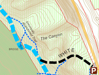
The Paugussett Trail had to be moved up the hill once again as a rapidly eroding gully ("the Canyon") advances up the slope. There are sharp, unstable drop-off at the head of the gully, which has now bisected the entire state park and is moving into Shelton Land Trust property. This is located near the main trailhead parking area across the street from the beach entrance, above the flight of 50+ steps. 

Head of the gully a few years ago, bridge at the upper right

This is how deep the head of the gully was in 2018

The bridge was formerly located 100 feet down the hill, but was moved up the hill to escape the advancing gully maybe 20 years ago. The Canyon has been relentless, however, and is nearing the bridge once again. 

Part of the latest relocation

A few years back, we did an emergency relocation on the north side of the bridge after discovering the deep trench-like gully near the trail. The head of the gully was so narrow at that point in time that is resembled a 10-foot deep construction trench. It was so narrow that you couldn't even see it until you were nearly in it. This year, it was the same scenario, but on the south side of the bridge. 

Previous trail relocations

The Canyon is impressive, and anyone interested in surficial or glacial geology should check it out. It would be a great location for a geology class field trip. The sandy soil here was once the bottom of a glacial lake, so some interesting cross bedding and other features were exposed:


Paugussett Reroute at Eversource Towers

New trail route avoids powerline work set for 2023

Two work parties were held in November to move a section of Paugussett Trail away from some powerline towers that will be replaced in 2023.  The trail reroute is located off of Buddington Road due west of John Dominick Drive. Eversource plans to install three new monopole towers there in 2023 and then remove the two existing towers as part of their Pootatuck Rebuild Project (Shelton/Monroe). With the new route, trail closures will be kept to a minimum. 


The old route went under this tower
The old route went directly underneath one of the Eversource towers after following the utility access road diagonally across the powerline and gasline corridor. The advantage was the solid ground. But it could also be a bit confusing, especially after mountain bikers created rogue trails in the area. It's hard to blaze a trail through the open terrain, and our marking posts placed along the utility road went missing. 

The old trail route, looking south
The new route crosses the powerline corridor to the north at the base of a rocky ledge, heading through lots of mountain laurel. The replacement towers will be located a bit further back from the ledge. 

The new route is located at the bottom of this ledge
(looking north)

Footing for the new route isn't as good as the old route, since part of it is squeezed between a wetland and the rocky ledge.  It's hard to say how the tread will hold up in that type of terrain. But after the construction of the new towers is complete, we always have the option of returning to the previous route if this new one isn't working out. 

The new route picks its way between wetlands to the north
and the rocky ledge to the south


Monday, November 21, 2022

Burritt's Bypass Trail at Birchbank Mountain

Burritt's Bypass Trail features a scenic cave

We have a new bypass trail at Birchbank Mountain designed to make the northbound journey between Indian Well and the Birchbank Overlook a bit easier. It also features a scenic cave. This is in the area known as Burritt's Rocks, which is precipitously steep and covered with boulder fields.  The Paugussett Trail descends 100 feet over the rocks, which can get slick. Some rocks can be challenging in a fun way to many hikers, but these are not those kind of rocks.  They're tedious when dry and hazardous when wet. The new trail finds a ways around most of the rocks by taking the high road, staying up near the top of the ridge above the boulders until arriving at better ground, then descending on packed earth. When hiking, it's best to go up the steepest option and down the more gentle route, so if you're doing an out-and-back hike, take Burritt's Bypass northbound and the Paugussett Trail southbound. 

Birchbank map showing the bypass trail


The new bypass trail is blazed blue/green


The new trail northbound descends on
packed dirt instead of rocks


The new trail is 0.23 miles long and is blazed blue/green. The rocky descent on the Paugussett  (if you are northbound) had been improved a few years back with a partial reroute, but the remaining portion can't easily be improved. It's no trouble going southbound uphill (see photo below), but when heading northbound downhill, your momentum can easily cause a slip and fall. So for most people, it's a tedious and potentially nerve wracking descent, especially if the rock is wet or you have a leashed dog that might tug at just the wrong moment.


Looking back up the Paugussett Trail
after descending down the rocks.
This is what the new trail bypasses.

Northbound from Indian Well, Burritt's Bypass begins at the top of a hill where the largest boulders are located (sometimes called "the cave rocks" because they form little caves). The blue/green blazes head up and around the largest rock and then soon rejoin a previous version of the Paugussett Trail where it passed by a substantial rock shelter or cave formed by an overhang.  At some point in the 1980s or '90s, a developer put forth a subdivision plan for the area just above this. Not knowing whether the trail might be cutoff suddenly one day, the trail managers shifted the Paugussett Trail down the rocky hill. It later turned out that most of the old route was preserved as open space, including the Birchbank overlook


Burritt's Bypass starts here, heading up to the big boulder
instead of down the rocky hill

The "cave" or rock shelter

A few years back, I found some old blue blazes at Birchbank from the former route and followed them to discover this scenic cave. It's not a true cave, but in Connecticut we call just about any rock nook a cave.  I thought it was a real shame that this feature was no longer accessible and pondered whether a new trail could be established to it.


An old blue blaze near the cave

This trail is not long, but the terrain has required a lot of work to make it worth hiking. There was a lot of digging and moving rocks on the south end due to the steep side slope.  


Lots of digging required!


Although it's less rocky than the Paugussett Trail, there are still plenty of rocks, including one boulder-filled section that looks worse than it is. Many boulders were moved from this section and the holes left behind filled in with smaller rocks and dirt carried up the trail in buckets. The boulder section is fairly level, and the rock is coarse-grained, so it's not too bad. Some hikers might view these as challenging in a fun way. 


A short rocky section

After that, the trail comes to the end of the boulder field and the slope becomes more gentle. This is where Burritt's Bypass makes the 100-foot descent to rejoin the Paugussett Trail. The trail curves back and forth down the hill in an effort to find the best footing and minimize erosion. Each direction change is a point where stormwater can exit the trail before it causes too much damage. 

Heading down the hill on Burritt's Bypass